RNP Constant Radius Arc Procedure
The departure and arrival procedures are codified in the AIRACs and provided in the Navdata. They change regularly which requires having a subscription to maintain consistency between the simulator, planes and related programs like Little Navmap, Simbrief, Aivlasoft...
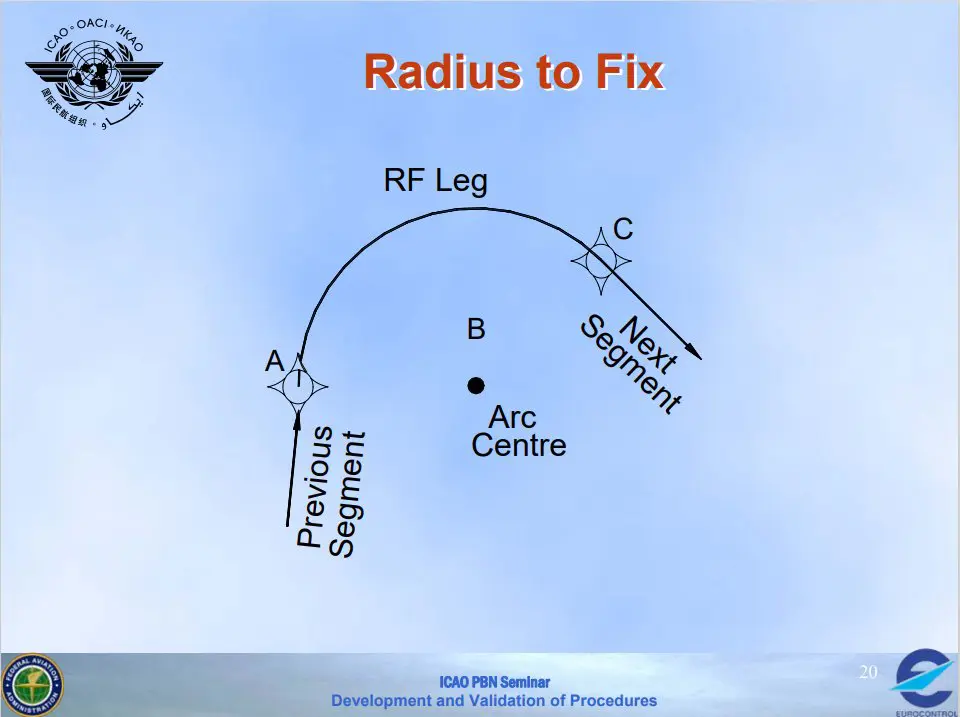
The codification of procedures is international and follows very precise rules. We have already explained some of them in this section, here is a new one: the procedure called "Constant Radius Arc" coded "RF".
This procedure allows an aircraft to follow a perfect curve around a central point, the trajectory being controlled by GPS.
Technical elements
This procedure is little used (we only found one in France, in Ajaccio): it is especially useful when you absolutely must not deviate from the road due to obstacles, such as in an airport surrounded by mountains, for example. It is also used when there are environmental problems.
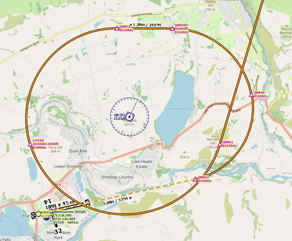
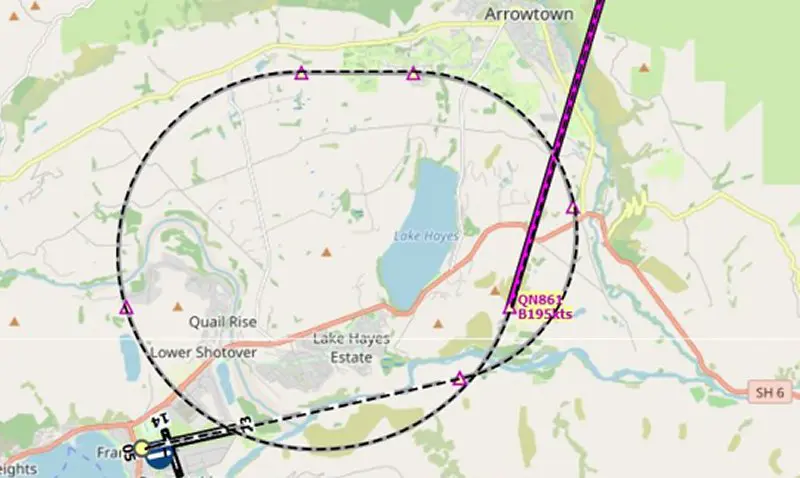
To find a concrete example, we had to go all the way to New Zealand in Queenstown Airport (NZQN)
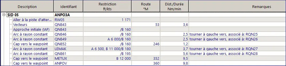
We have selected the RNAV SID "ANPOV 3A" departure procedure, here is the plot on Little Navmap. Four circular arcs have been created so that the planes were at the desired altitude to exit the procedure area. The speeds imposed are low enough to ensure that the radii of bends are maintained.
The coding of this procedure in the Navdata is as follows:
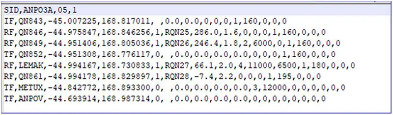
It uses two segments of two RF arcs:
- the first is delimited by the points QN843 and QN849 via QN846
- the second via points QN852 and QN861 via LEMAK
The centers of the circles are represented by the codes RNQxx. These particular waypoints are found in the AIRAC database of Navigraph. They only appear on FMS.
The take-off circuit being very steep, the trajectories must be followed with the greatest precision. These two loops also manage speeds and altitudes so that the exit is done without the risk of hitting a mountain.
Note that, in the real world, not all aircraft have the necessary equipment to perform this type of procedure.
And in our simulator?
We tested it with two planes: the A320 from Fenix and the A32NX-dev from FBW. The flight was created with Simbrief and tracked with Little Navmap.
the A320-Fenix at Queenstown
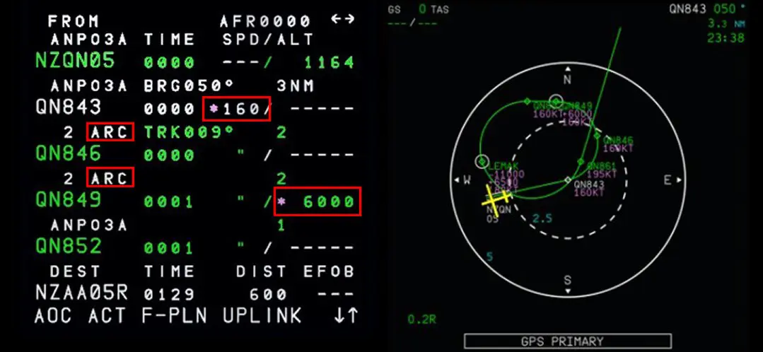
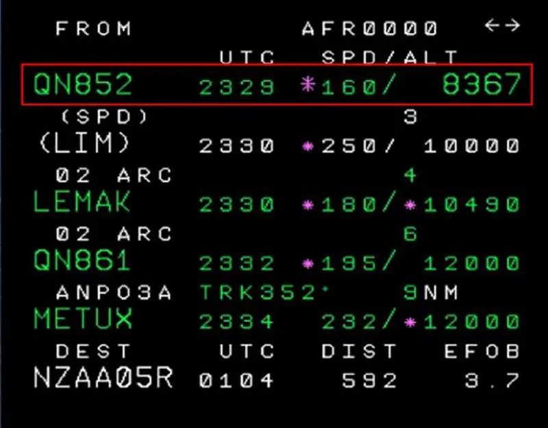
By selecting this departure (track 05), LNM provides us with the following detailed elements:
NB: the LNM data is more explicit than the coded AIRAC lines.
The speed (< 160 kts, ...) and altitude (]6500 ft, 11000 ft[, ...) constraints appear clearly.
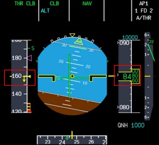
The flight plan was then loaded into the MCDU of the A320, which gives the ND the following layout and constraints:
1 - A320 FBW: everything is included in the MCDU.
2 - A320 Fenix: no difference (QN is a VOR).
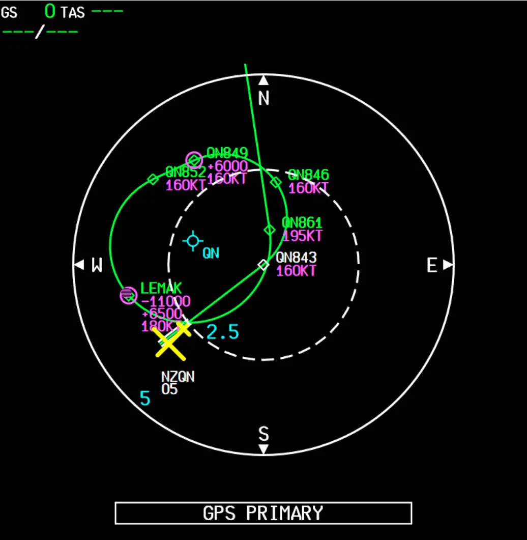
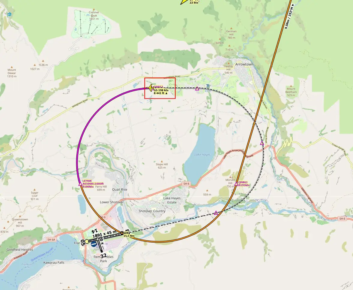
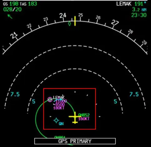
For the two planes, the trajectories and constraints are perfectly respected which gives, in the middle of the trajectory (point QN852), the following trace.
It can be checked on the PFD and the ND that the speed (160 kts) and altitude (aircraft climbing between 6500 and 11000 ft) constraints are respected.
And, at the end of the procedure: perfect!
Although this type of segment (Leg RF) is little used, it is fully taken into account by the two Airbus A320s:
- the free,

and the one you have to pay.

Codification of arcs of circles (for those who want to understand everything)
The data corresponding to the centers of the circles does not appear on the maps or in the FMS. They are provided with the AIRAC in the "Waypoints" database as shown below:
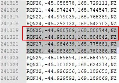
The 2 WP (centres of the arcs) circled in red will be used to explain how it works.
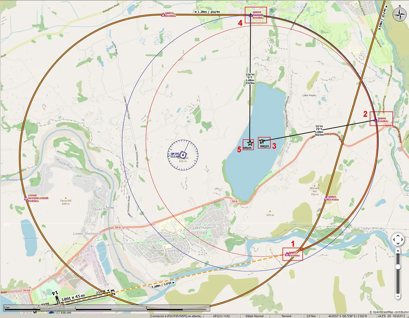
We have placed these two WPs on the ANPOV 3A procedure chart for Queenstown Airport (NZQH) in New Zealand.
These 2 WPs are therefore used in the "Radius to Fix" procedure of the 2 RF coded lines circled in red:
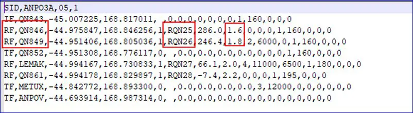
This procedure having 2 RF lines, there are therefore 2 arcs of circles with different centers: RNQ25 and RNQ26
Explanation:
Point 1: QN843 (coded IF for Initial Fix) is the entry point in the first arc.
Point 2: QN846 (RF coded) is the exit point of the first arc and entry into the second arc.
Point 3: RQN25 is the center of the first arc of radius 1.6 NM (red circle)
Point 4: QN849 (RF coded) is the exit point of the second arc.
Point 5: RQN26 is the center of the second arc of radius 1.8 NM (blue circle).
There you go, this procedure, recent at the ICAO (2009) and very recent at Navigraph (2022), no longer holds any secrets for you.
To understand its advantage over a "FlyBy" type turn:
https://www.icao.int/MID/Documents/2014/PBN%20Go-Team%20Visit/05%20-%20PBN%20Airspace%20Workshop_NAV%20spec%20+%20proc%20design.pdf