Landing at VQPR on runway 15 (Paro, Bhutan)
This flight, initially, is part of one of the challenges offered by FS2020. Nevertheless, the challenge "delivers" the aircraft to you once the approach is largely engaged,
aircraft configured and ready for landing with only two manual turns left. Landing, however, remains of course a real challenge.
The purpose of this tutorial is to show you how to carry out all the previous actions, in the way that seems to us the least complicated possible, to reach this particular "delivery" point and of course,
finish with a landing on runway 15.
Add-ons used for this tutorial:
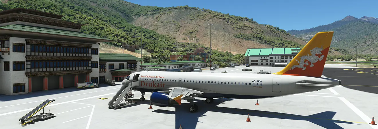
- A320 Fenix V.1.0.6.146,
- A320 FenixDrukair livery (free add-on) from the real company serving this airport,
- Pakyong Airport (free scenery that some users may have defects of double display of runway markings),
- Paro Airport (free scenery),
- Approach sheet of the destination found on the web.
The few dozen tests that were necessary to develop this tutorial have shown that both the A320 FBW and the A320 Fenix do not behave satisfactorily on this approach. The FBW absolutely does not know how to manage this type of approach whereas the A320 Fenix can behave differently or even totally erratically from one approach to another, such as adopting a slope of initial descent much too pronounced then not triggering the descent at all during the following test when the flight conditions were strictly identical. It is therefore perhaps not even written that you will be able to reproduce this sequence of procedures in the same way as we are going to describe it to you.
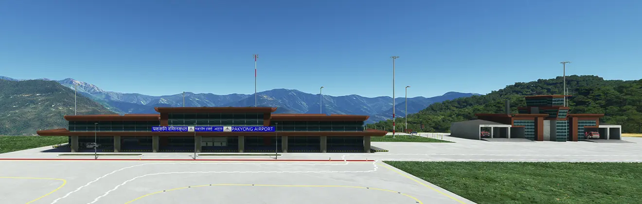
We imagined a departure from Pakyong airport in India (code VEPY, one of the closest to the final destination) about 15/20 minutes flight from Paro, the exclusive purposes of the flight being the
achievements of the approach and landing deemed the most dangerous in the world (8 qualified pilots according to Wikipedia).
As such, it is obvious that to attempt, execute and succeed such an approach, the level of the user must be accordingly: not suitable for beginners 😉.
The bulk of the work will essentially consist of preparation on the ground, before starting up and checking the insertions in the FM, the flight itself will be done mainly by the pilot automatic while monitoring the smooth running of operations as planned.
As we are going to land at an airport located at an altitude of more than 7000 feet and the cruise will take place at 17000 ft, we can consider that the entirety of this very short flight will take place below the symbolic limit of 10,000 ft/ground "facilitating" operations a little and reducing normal actions as much as possible: the landing lights and instructions will be ON throughout the flight and we could also limit the speed to 250kt (by displaying it in selected speed), but for educational purposes, we leave it in managed in order to let the plane control its speed.
VEPY (Pakyong)
VQPR (Paro)
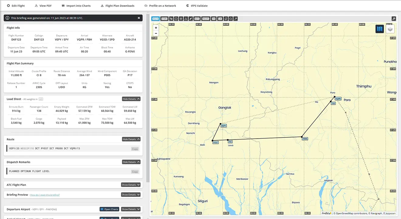
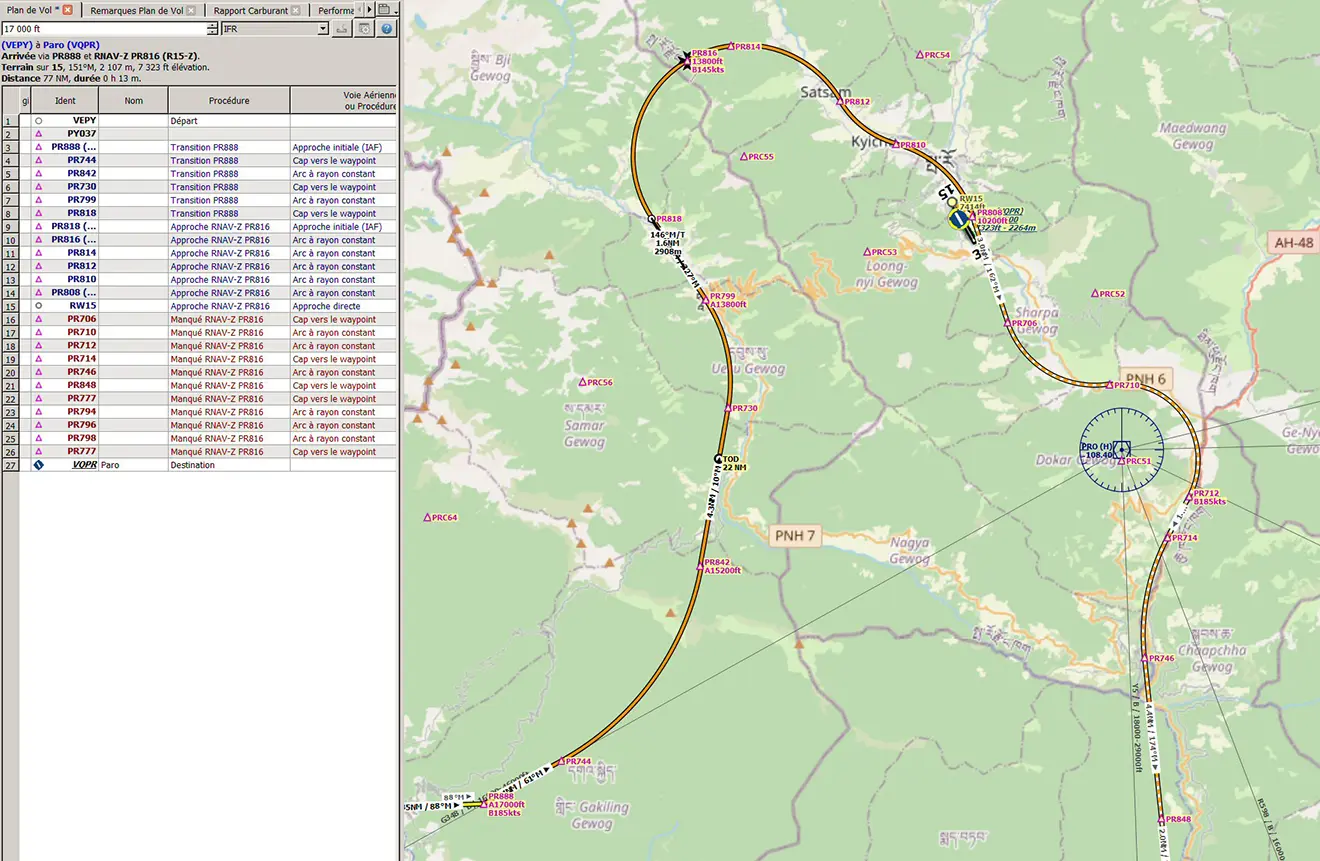
1 - The Simbrief flight plan: VEPY PY037 PR888 VQPR
2 - The same LNM flight plan with the RNAV-Z-15 approach procedure and the PR888 to VQPR transition
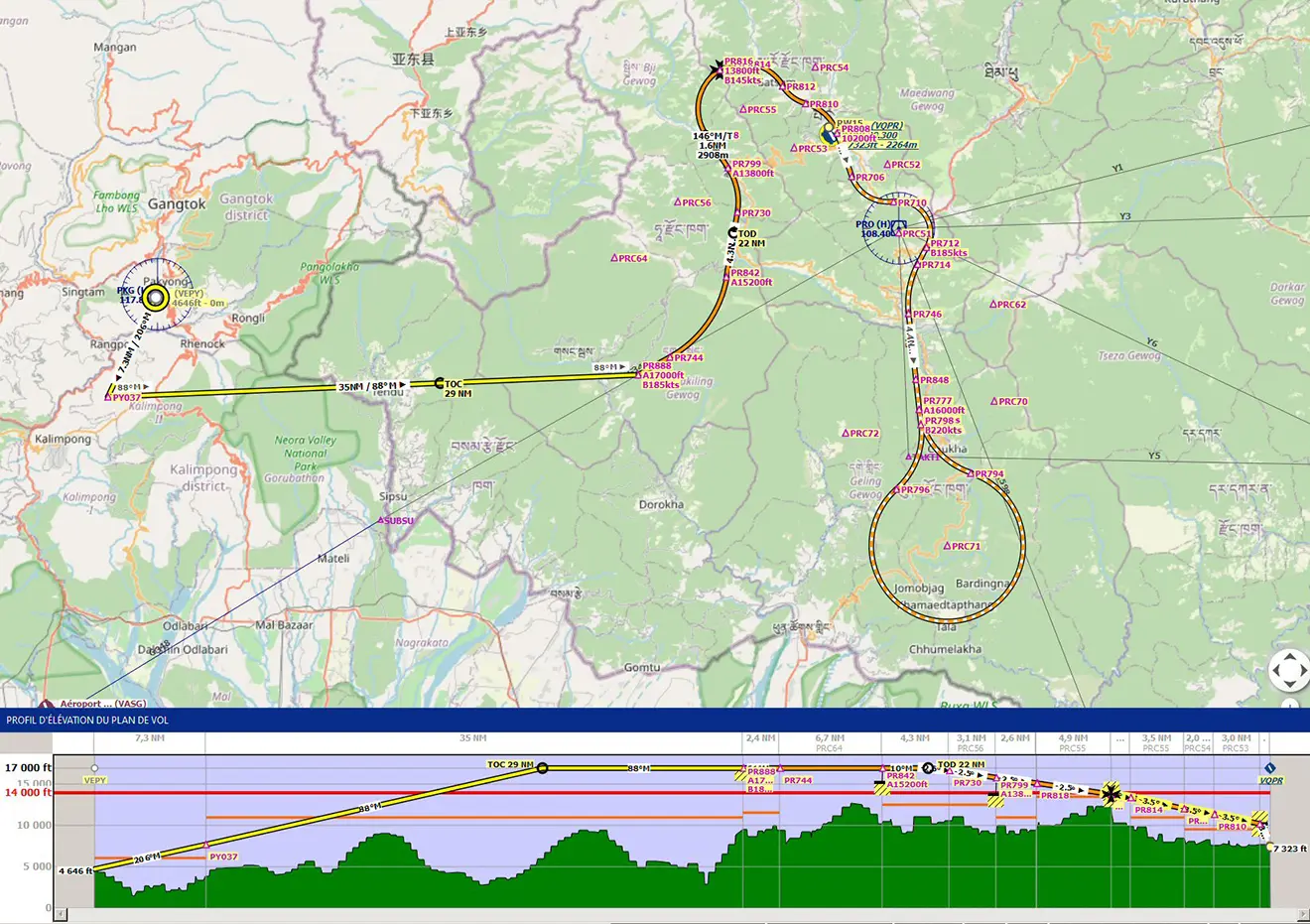
Zoom on the finish: 7 legs called "Constant radius arc" (RF codification, see tutorial), 9 NM to descend from 6450 ft
3 - The flight plan inserted in the FM (either imported from Simbrief, or entered "by hand", "minimal" insertions below):
INIT A page:
Start/Finish: VEPY/VQPR
ALTN, FLT NBR, COST INDEX, TROPO: as desired
CRZ FL: 17000 (which will turn into FL170)
GND TEMP: of the day
F-PLN page:
Departure: VEPY runway 20, NO SID
Arrival: VQPR RNAV 15Z, NO STAR, via PR888
Between the departure and PR888, we can insert the point PY037 (27N/089E - optional)
Erase discontinuities.
INIT B page:
ZFW / ZFWCG / FOB: of the day
PERF page:
The calculation of take-off performance not being the subject of the day, the performance will be inserted with "standard" values such as 120/125/128 and a fairly low flex temperature
(but greater than or equal to the ground temperature of the day) for the engines to deliver enough power (remember that the terrain of VEPY is at 4646 feet
[QNH to be displayed accordingly...], relatively high, engine performance on take-off will necessarily be degraded).
The planned flight time being particularly short (fifteen to twenty minutes), we will also take the opportunity to insert the performance of the ATTR page (weather data exists for the terrain destination so if you decide to fly in real conditions, insert the real values of QNH, ground temperature and wind). No need to fill in the BARO line because the approach will end visually (however you can always insert a value 200 ft above the altitude of the destination airport, i.e. 7364+200 ≈ 7570).
FCU:
Target altitude 17000 feet
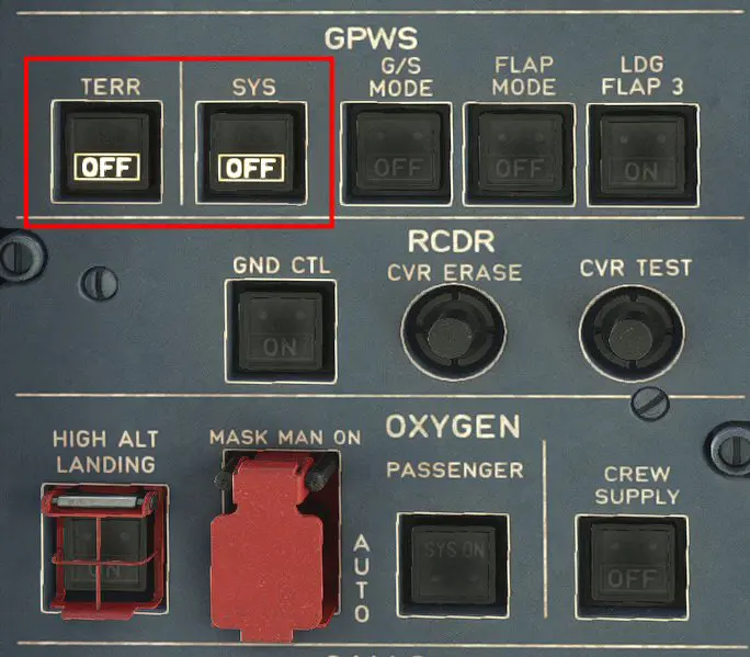
In order not to generate untimely (but real) alarms, care should be taken, on the upper panel, left side, GPWS line, to set the TERR and SYS buttons to OFF.
Presentation and checks of the constraints (speeds and altitudes of passages) of the various points of the procedure:
We may, on occasion, note the difference between constraint (an imposed altitude or speed at a particular point) and a prediction.
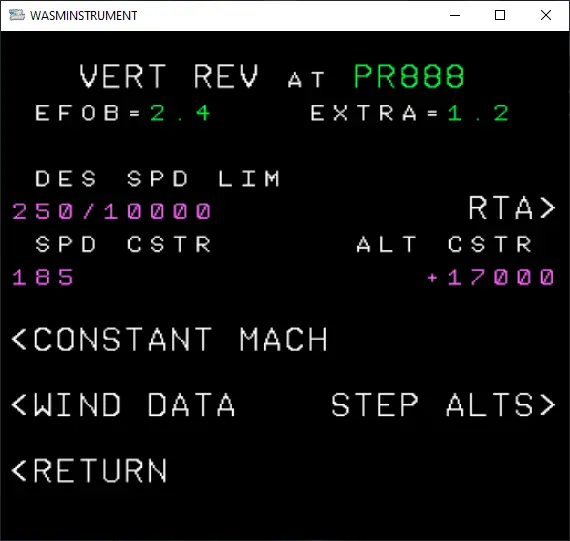
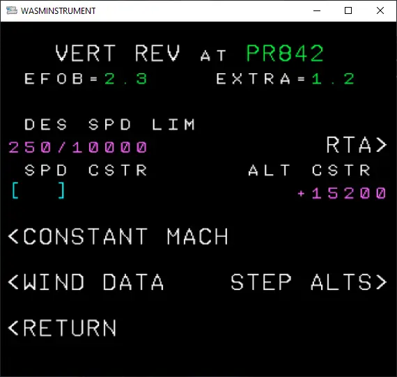
Example: at point PR842, the constraint is to pass there at more than 15200 feet (indication in magenta +15200 on the VERT REV page of the point in question) while the prediction (the FM predicts that the plane would actually pass at xxxx feet, while respecting this constraint...) is 17,000 feet.
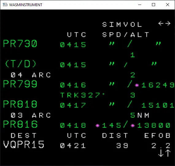
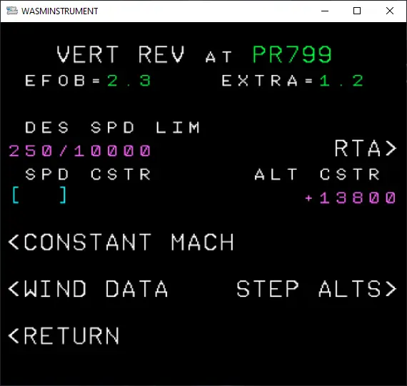
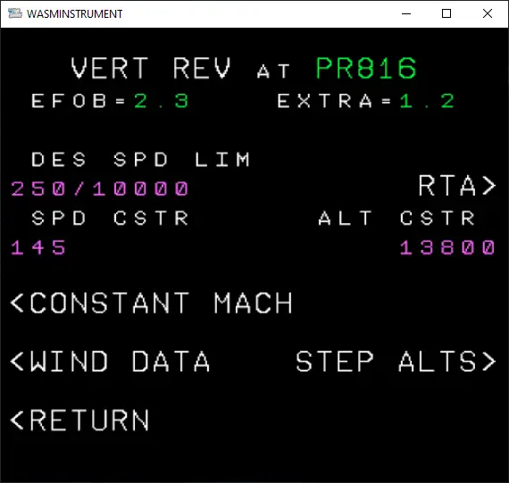
(Same for point PR799 with 15101 iso +13800)
The goal for the FM will be to "smooth" the descent, i.e. to program a descent as continuous as possible to avoid too rapid a loss of altitude and/or temporary thrust.
very fuel consuming.
4 - Detail of the autopilot approach:
Almost the entire approach will be PA (freeing up resources to monitor everything else!).
We relied on the RNP Z 15 sheet.
Which gives the following approach:
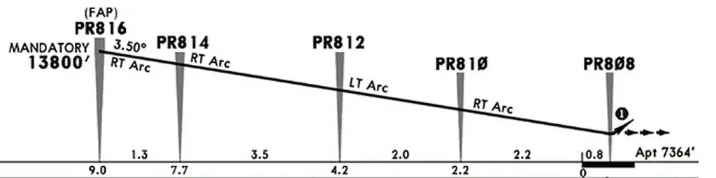
We calculated the slope required to start from the pass at the requested altitude (PR816 at 13,800 feet) to the runway threshold (at 7,364 feet), i.e. Δ FL = 13,800 – 7,364 = 6,436 feet.
This loss of altitude must take place over 9 NM (distance indicated directly under the approach profile, up to the runway threshold).
The formula to use is the same as to calculate the descent point when you are in cruise, namely:
D (NM) = Δ FL / Plane (°)
We deduce the following formula:
Plane (°) = Δ FL / D (NM)
Applying to the current case:
Plane (°) = 6436' / 9 = 715.111 or 7.15° (and also 715 feet / NM)
This is more than 2.5x the slope of a Standard ILS approach (3°). That's huge!
Which also means that to follow this plane, it will take 2.5x the "normal" sink rate of a standard ILS approach.
With such a sink rate, it is almost impossible for the aircraft to maintain the selected and predicted speed and will most likely accelerate on its path. This is the limit of such an approach for which we have few "defenses" to counter this acceleration (for information, on A319 and A320 the output of SpeedBrakes is inhibited in conf. FULL. There is therefore no need to try to pull them out once the flaps are fully extended (this will immediately trigger an alarm).
The goal is therefore to bring the aircraft to its approach speed and with all the drags extended (flaps and landing gear) at the descent set-up point (PR816), i.e. at 13800 feet, because after this point, the aircraft will no longer be able to decelerate due to the significant vertical speed due to the unusual slope).
Airbus calls this maneuver an Early Stabilized Approach. In this way, the acceleration of the aircraft due to the excessive rate of sink will be minimal (but very present and to be monitored).
We will not use the APPR key because the approach is coded in the FM under a slope of 3.5° (as indicated on the approach sheet), which is therefore largely insufficient to "make the track" but we will use the TRK/FPA button located above the AP engagement buttons.
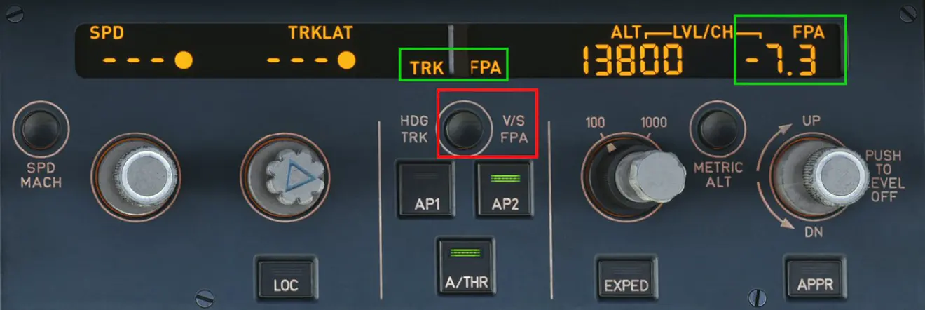
Pressing this button changes:
- FCU display,
- The representation of the FDs on the PFD which switches to BIRD representation.
And above all, this allows us to display a glide path (FPA = Flight Path Angle) with the FCU's right rotary switch. We displayed 7.2 (for the 7.15°) to save ourselves a small margin (in this case, it is better [despite the rather "poorly paved" topography] to be slightly below the trajectory and possibly tell yourself that you will have to slow down the descent if you are a low hair than being above the profile and having to "push" on the stick close to the ground to catch up with the plane).
Be careful not to display the -7.2° too early, because the display clears itself after a few tens of seconds.
The descent is initiated by pulling on this same button, if you push it, it stops the descent (it's marked right next to it: "PUSH TO LEVEL OFF"). Airbus recommends pulling the button question 0.3 NM before the desired point of descent, the time for the modes to engage and the airplane to begin descent.
As the plane is still in NAV mode, we know that it should follow the horizontal trajectory drawn on the map following the planned turns (but that does not exempt us from checking that it does it well) and it will descend vertically on the indicated plane. The advantage of this mode is that we follow a plane at x°, independently of the wind which, however, may influence on the aircraft's sink rate.
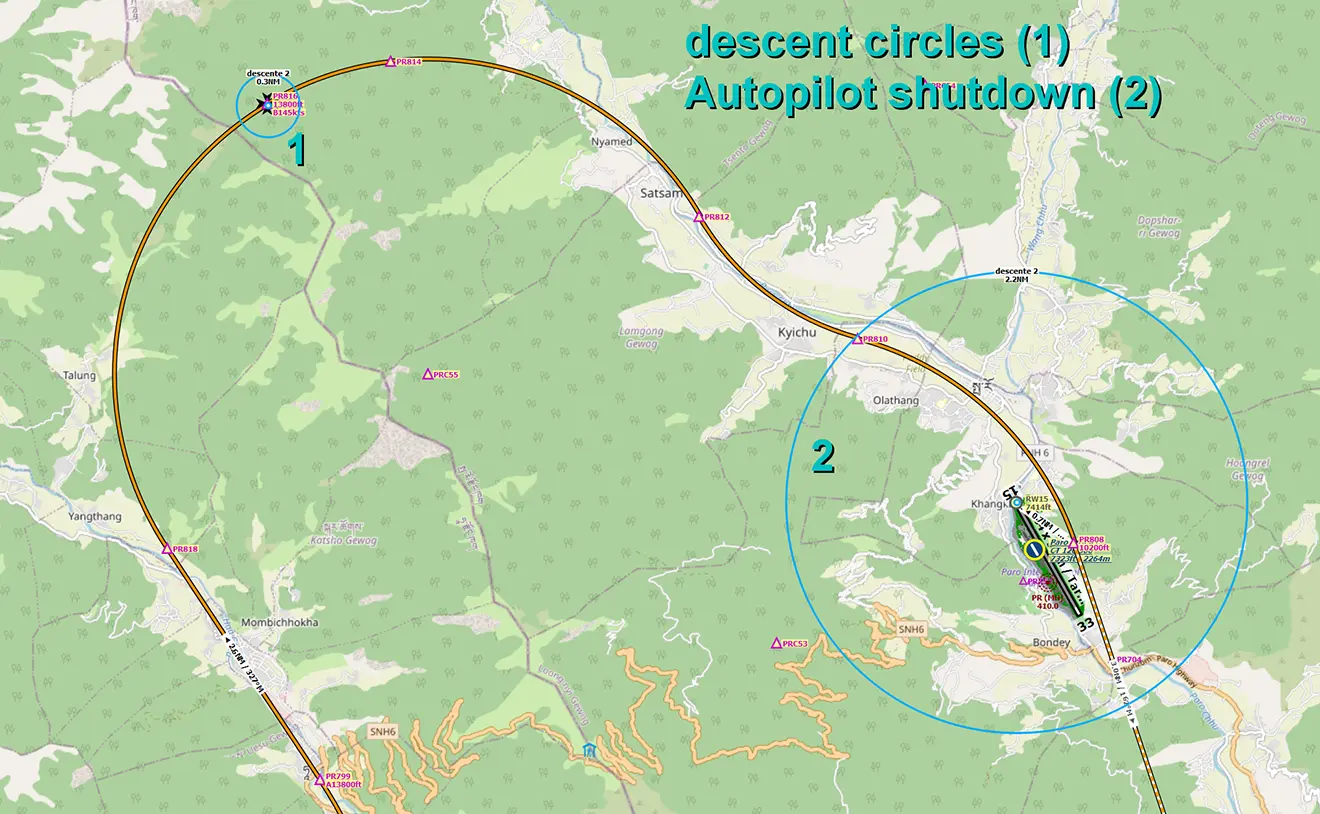
The end of the landing is done manually by cutting off the AP using the "instinctive disconnect" button (the red button on the stick) at point PR810, the last point of the RNAV procedure, while keeping the ATHR active to let it manage the maintenance of the speed and the engine speed and by cutting the FD.
5 - Video of the flight: (on our Youtube channel) https://youtu.be/LHXDqQbYnhs
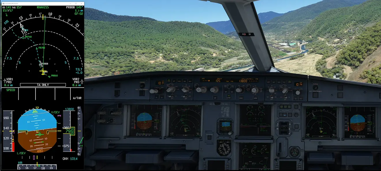
NB: for better reading, the PFD and ND screens have been moved to the left side of the video.
Timing of actions performed in the video:
The video begins when the aircraft is at cruising speed and altitude (FL170) en route to point PR888. The destination airport being over 7000 feet above sea level, we could have considered that the aircraft was at an altitude of less than 10,000 feet and voluntarily limited the speed to 250 Kts as provided for in the operations manuals of many companies. We deliberately chose to let the FM handle this speed to show you how the aircraft handles stress.
On the ND screen we can see on the route the point ETP (EquiTemPs) which marks the point where it will take the same time to reach the arrival point or the departure point of the flight. We can also see a Magenta colored dot which marks the position estimated by the FM for the start of speed reduction for the aircraft to reach its first target speed of 185 kts at point PR888 (as indicated on the approach chart).
At 00:08, consultation of the Fuel Pred page to calculate the weight of the aircraft on landing (here, ZWF 52.5 + EFOB 3.1 = 55.6 T).
From 00:12 to 00:33, introduction of parameters in the landing distance calculation page of the EFB, then choice of braking means. The selected autobrake will be the MED position which will be selected at 00:36.
At 00:38, the FM decided to reduce the speed to 185 kts (very slightly ahead of passing the Magenta point).
From 00:46 to 00:56, passage of the 3 altimeters at QNH and pre-display of the target altitude of 13800 feet.
At 01:38, change of scale on the ND to better visualize the future trajectory.
We can see on the PFD that the speed GD (Green Dot, at 198 kts) as read at this time and materializing the minimum speed that the airplane can adopt in clean version (without slats or flaps extended)
does not allow the speed of 185 kts to be reached (the aeroplane, as long as the A/THR is active, will not allow automatic reduction below this speed limit).
A pilot action is therefore required at 02:02 to extend the flaps in CONF 1 in order to allow this reduction in speed down to speed S of 189 kts.
Simultaneously, display of the Status page (automatic when exiting the flaps when it is not blank) to recall the "failure" equipment, namely the EPWS that we have voluntarily
cut off at the start of the flight so as not to trigger nuisance alarms.
At 02:19, just after passing PR888, pressing the altitude management button to switch to DES mode which, in theory, should allow you to descend while respecting the different altitude constraints of the procedure. It turns out that during all the tests carried out, the plane did not respect these constraints. It was either slow to come down with variations constant engine speed (case of the video presented) or triggered a continuous descent towards 13800 feet without respecting the following constraints (and particularly the passage to 15200 feet at point PR842).
At 00:48 switch to CONF 2 to allow the aircraft to adopt the planned speed of 185 kts (and drop below S).
Disorderly behavior to follow with a "complicated" management of the descent (even leading to a climb!) and of the speed by the FM.
At 05:44, gear down and activation of approach mode on the FM. The target speed then becomes 130 kts (visible on the PFD).
At 06:08 exit CONF 3.
At 06:33, switch to TR/FPA symbology and pre-display (*a little too early in the video...) of the -7.2° which will be necessary for from PR816.
At 06:58, switch to CONF Full then lighting of the headlights and arming of the Speed Brakes (actions that should have been carried out when exiting the train).
At 07:54, correct stabilization of the altitude (by putting the engines into thrust) by the FM which then kept the 13800 feet displayed on the FCU.
At 08:02, *disappearance of the display of -7.2°
At 08:14, triggering of the final descent by redisplaying -7.2° then pulling the button. Ideally, this descent should have been carried out 0.3 NM from PR816, it was performed a few seconds late but had no effect on the rest of the approach.
PLEASE NOTE:
- CAUTION: as carried out, this approach does not include a "safety net": the aircraft will continue its descent below 7.2° until it eventually hits the ground if there is no action from the pilot!!!
- Even if the approach was started at the planned speed of 130 kts, to continue to maintain its glide path, the aircraft will gradually increase its speed up to 155 kts
(and its rate of descent).
At 10:28, passage of 2000 feet / ground in descent which triggers the C/L before landing.
At 10:50, AP and FDs off (alarm off).
The rest is "only" piloting by hand.
At 11:50, touchdown (really short) and slight bounce on landing.
Release of the reverses (superfluous given the calculated landing performance and the touchdown point far upstream of what it should have been).
For real video illustration in A319-112 registered A6-RIM : https://www.youtube.com/watch?v=3C4pyU6lpWM